ABSTRACT
Vehicular adhoc Networks (VANETs) enable vehicles to communicate with each other as well as with roadside units (RSUs). Although there is a significant research effort in radio channel modelling focused in vehicle to vehicle (V2V), not much work has been done for vehicle to infrastructure (V2I) using 3D ray-tracing tools.
This work evaluates some important parameters of a V2I wireless channel link such as Received Power, Power Delay Profile, Delay Spread and Coherence Bandwidth, in an urban scenario using a deterministic simulation model based on an in house 3D Ray-Launching algorithm. Analysis using Wireless Sensor Networks (WSNs) at 868MHz, 2.4 and 5.9 GHz are presented. Results show the highly impact that the distance, link frequency, location of RSUs and obstacles in the LoS (Line of Sight) have in V2I channel propagation. These results constitute the start point in the deployment of radio-planning in V2I environments.
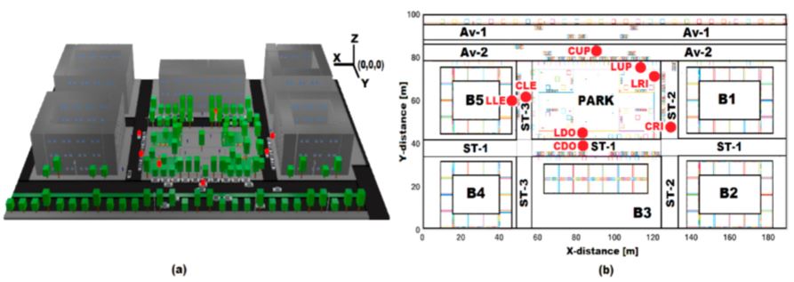
Figure 1. Scenario characterized where (a) is 3D frontal view and (b) is 2D back-view
SIMULATION URBAN SCENARIO
The ray launching tool incorporate a database of geographic data such as vegetation, terrain, buildings, park-benches, cars, pedestrians, avenues, streets, sidewalks of urban scenario modeled and characterized as a replica of Plaza de Góngora (42°47′52.72′′ N, 1°38′21.14′′ W) located in Pamplona, Spain. The area encompasses 380,000 m3 (190 m × 100 m × 20 m) of scenario, and includes: 1 park, 2 motorway avenues, 3 secondary streets, 5 buildings (20 m high), 8 park-bench, 8 medium lamp posts (7 m high), 13 high-lampposts (10 m high), 16 pedestrians, 45 cars, 100 trees and many sidewalks; each of them have its own electromagnetic characteristics for the 3D RL algorithm.
RESULTS
![Figure 2. Received Power [dBm] at Z-plane of 1.5 m when: (a) the frequency of Tx-LUP is 2.4 GHz and (b) the frequency of Tx-LDO is 5.9 GHz](http://cse.final-year-projects.in/wp-content/uploads/2017/12/p-02552-Characterization-of-Radio-Propagation-11.jpg)
Figure 2. Received Power [dBm] at Z-plane of 1.5 m when: (a) the frequency of Tx-LUP is 2.4 GHz and (b) the frequency of Tx-LDO is 5.9 GHz
CONCLUSIONS AND FUTURE WORK
Deterministic modelling such as RL are an excellent tool to obtain an adequate estimation of channel propagation parameters in the different parts of the scenario considering all its constituent elements with the aim to deploy an optimal configuration of WSNs in terms of coverage. A 3D in house ray-launching tool has been used, which enables an accurate evaluation of RP, PDP, RMS delay spread and CB in the context of V2I environments, using WSNs at frequencies of 868 MHz, 2.4 GHz and 5.9 GHz.
In general, factors such as distance from Tx, link frequency, location of RSUs and, obstacles in the LoS will have profound impact in the V2I channel propagation. It is observed lower RP and higher dispersion signal levels at 5.9 GHz. The higher the obstacles in the LoS, the higher the power loss: the buildings yield the more significant power loss, however, they induce the well-known phenomenon of wave guide effect along the streets, which should be taking into account in the deployment of RSUs at intersections. At least 2 RSUs located at specific street intersections are needed to provide optimal V2I wireless communication in terms of coverage.
As a future work, a measurement campaign should be considered for the urban scenery in order to contrast the 3D RL simulation results, with test-field measurements.The identification and characterization of significant areas (i.e., different density of obstacles as buildings, vegetation, etc.) could lead us to the proposal of an empirical or statistical propagation model that account more environmental variables with the aim of precise results. Geographical area (zone2) with high CB and low RP levels where the V2I communication is unable, could be of special interest in research fields as cognitive radio, V2P, etc.
Source: University of Navarre
Authors: Fausto Granda | Leyre Azpilicueta | Cesar Vargas-rosales | Peio Lopez-iturri | Erik Aguirre | José Javier Astrain | Jesus Villandangos | Francisco Falcone
>> More Wireless Sensor Networks Projects Abstract for Engineering Students