ABSTRACT
In this work, we investigate the sea surface monitoring capabilities of a Synthetic Aperture Radar (SAR) system equipped with a three-antenna hybrid Across Track (XT)/Along Track (AT) inteferometric configuration. To do this, we focus on the X-Band airborne InSAeS4 SAR system. Moreover, we propose a simple but effective methodology that allows simultaneous retrieval of the sea surface height and velocity by means of a straightforward, easy-to-implement, linear inversion procedure, which is very general and can be implemented with any system equipped with a three-antenna hybrid XT/AT Interferometric SAR (InSAR) configuration.
In our case, we present an experiment carried out in January 2013 in South Italy over the coastline stretch of the Campania region including the Volturno River outlet. In this regard, we highlight that in situ measurements of the retrieved sea surface height and velocity at the time of the airborne mission are unfortunately not available.
Notwithstanding, the obtained results show some interesting evidence that the estimated quantities are physically sound. This, on the one side, provides a preliminary validation of the effectiveness of the overall presented methodology and, on the other side, highlights the potentialities of the three-antenna hybrid XT/AT InSAR configuration of the InSAeS4 system for sea state monitoring.
SYSTEM DESCRIPTION

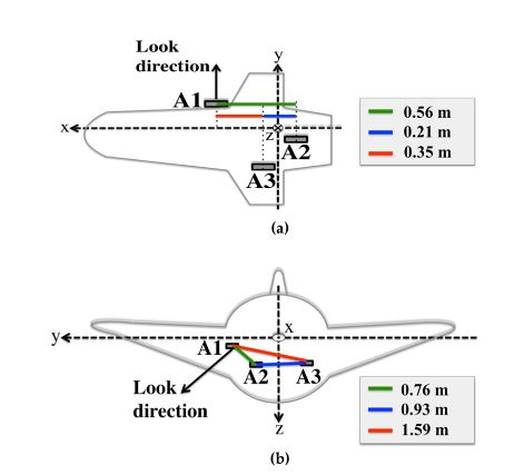
Figure 1. The interferometric layout of the InSAeS4 system. The Three antennas are denoted as A1, A2, and A3
The system is equipped with a hybrid XT/AT InSAR configuration consisting of three antennas installed on board in such a way to allow the simultaneous presence of three AT baseline components (which, in the absence of pitch an d yaw, are equal to 0.56 m, 0.21 m and 0.35 m, respectively), and three XT baseline components (which, in the absence of pitch and yaw, are equal to 0.76 m, 0.93 m and 1.59 m, respectively). For the sake of clearness, the antenna layout is depicted in Figure 1.
RATIONALE OF THE PROPOSED METHODOLOGY
In the following, for the sake of generality, we will consider the airborne SAR case, thus assuming the sensor velocity and the squint angle not constant during the acquisition. In this regard, we underline that the output SAR grid is chosen hereafter with respect to a nominal one, that is rectilinear, representing the reference track relevant to the actual master track.
EXPERIMENTAL RESULTS

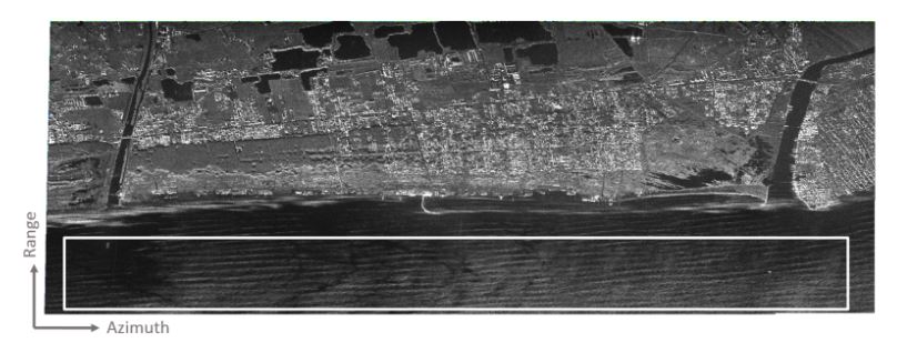
Figure 2. Multi-look amplitude SAR image relevant to the acquired data. Spatial resolution: 6 m × 5 m (slant range × azimuth)
SAR data have been transmitted with 100 MHz bandwidth. Table 3 collects the main mission and data processing parameters. Figure 2 shows one of the three focused multi-look SAR images, where a 4 × 32 (range × azimuth) pixel averaging (leading to a resolution of 6 m in slant range and 5 m in azimuth) has been applied. As can be seen, the test area, which is about 7 km long and almost parallel to the coastline, includes both sea and land regions.

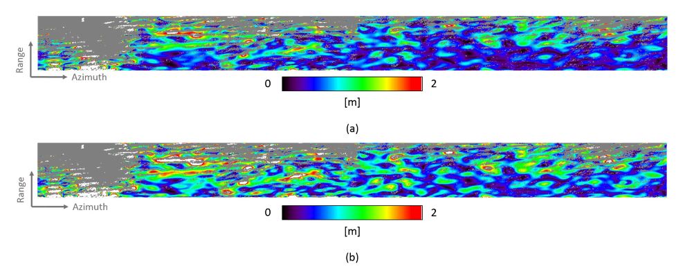
Figure 13. Envelope of the filtered sea surface height map of Figure 10c
As can be seen, we have obtained a quite good agreement between the sea wave amplitude retrieved from an (even rough) available bathymetry profile and the estimates provided by our procedure. This good agreement is preserved if we move from the single range cut to the whole ROI. In particular, in Figure 13 we show the envelope of the estimated sea surface height (Figure 13a) and its counterpart normalized to the theoretical wave amplitude obtained from the available bathymetry through the expression in Equation (9) (Figure 13b).
CONCLUSIONS
In this work, we have investigated the sea surface monitoring capabilities of a three-antenna hybrid XT/AT InSAR configuration. To do this, we have focused on the on the X-Band airborne InSAeS4 SAR system. Moreover, we have proposed a very general methodology, which can be implemented with any system equipped with a three-antenna hybrid XT/AT InSAR configuration and allows simultaneous retrieval of the sea surface height and velocity through a simple linear inversion procedure.
In addition, to improve the achieved sea surface height and velocity estimates, an effective filtering procedure tailored to the local properties of these sea parameters has been presented. The shown results are relevant to a dataset acquired by the InSAeS4 SAR system in South Italy over the coastline stretch of the Campania region including the Volturno River outlet. Although in situ benchmark measurements provided by buoys or similar instruments and relevant to the time of the considered airborne mission are not available, the obtained results show some interesting evidence that the estimated quantities are physically sound.
More specifically, we have verified that the estimated velocity of the observed scene is approximately zero in correspondence of the land region. Although the paper is focused on marine scenarios and not land, this result is however interesting because it represents a good first order check of the effectiveness of the proposed procedure in separating the XT and AT contributions present in the interferograms generated through the considered three-antenna hybrid XT/AT InSAR system.
Source: Cambridge University
Authors: Antonio Natale | Giuseppe Jackson | Carmen Esposito | Gianfranco Fornaro | Riccardo Lanari | Stefano Perna