ABSTRACT
3D spatial data acquired from aerial and remote sensing images by photogrammetric techniques is one of the most accurate and economic data sources for GIS, map production, and spatial data updating. However, there are still many problems concerning storage, structuring and appropriate management of spatial data obtained using these techniques. According to the capabilities of spatial database management systems (SDBMSs); direct integration of photogrammetric and spatial database management systems can save time and cost of producing and updating digital maps.
This integration is accomplished by replacing digital maps with a single spatial database. Applying spatial databases overcomes the problem of managing spatial and attributes data in a coupled approach. This management approach is one of the main problems in GISs for using map products of photogrammetric workstations. Also by the means of these integrated systems, providing structured spatial data, based on OGC (Open GIS Consortium) standards and topological relations between different feature classes, is possible at the time of feature digitizing process. In this paper, the integration of photogrammetric systems and SDBMSs is evaluated. Then, different levels of integration are described. Finally design, implementation and test of a software package called Integrated Photogrammetric and Oracle Spatial Systems (IPOSS) is presented.
NECESSITY AND IMPORTANCE OF SDBMS AND PHOTOGRAMMETRIC SYSTEMS INTEGRATION
Central Database Instead of Digital Maps
Nowadays, the methods used by most organizations for producing spatial data using photogrammetric techniques store data as a digital map. These digital maps are produced at special scales and for defined applications. Therefore, features displayed in these maps, are selected based on its specific application and do not include all features in the field. In this case, spatial data must be collected again for producing maps with different applications, or generalization operations should be carried out for generating maps at smaller scales. Both of these steps are costly and time consuming.
INTEGRATION OF PHOTOGRAMMETRIC SYSTEMS AND SDBMSs
Integration of photogrammetric systems and SDBMSs is a new approach and there is a few researches in literature on this field. Woodsford has evaluated integration of the systems and explained the necessity of a new method for direct integration of them. Also Heipke has described integration of photogrammetric systems and SDBMSs as a requirement which an ideal GIS must meet to cope with the challenges of the future.
The method which already has been used in commercial systems is indirect integration (File Based Exchanging of Spatial Data). In this method, no direct relationship is available between the photogrammetric system and the SDBMS, and an integration process is carried out via file based exchanging of spatial data. These files are outputs of photogrammetric systems in Computer Aided and Design (CAD) or GIS standard formats.
DIRECT INTEGRATION OF PHOTOGRAMMETRIC SYSTEMS AND SDBMSs
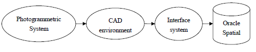
Figure 1. CAD environment as an interface for receiving data points sent from photogrammetric systems
Nowadays, most photogrammetric systems use standard CAD environments as their digitizing environment. In these photogrammetric systems, data points extracted from photogrammetric models are sent to the CAD environment via a device called Stereo-link. Currently, most CAD environments such as AutoCAD and Microstation support programming languages with OLE capabilities. Thus, according to the limitations mentioned for the photogrammetric systems, CAD systems can be used as an interface to receive data points (Figure 1).

Figure 2. Main structure of the interface system
For direct integration of Oracle Spatial with photogrammetric systems which use Microstation for the feature digitizing operation, the interface system should have the following characteristics and capabilities:
- Receiving 3D points extracted from the photogrammetric model simultaneously during feature digitizing process from aerial and remote sensing images.
- Producing structured data sets from received points according to OGC standards and topological relations between features in the real world
- Generating required tables for storing spatial and attribute data and retrieving them seamlessly according to the user requirement.
- Storing spatial and attribute data in a recognizable format by Oracle Spatial
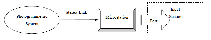
Figure 3. Main structure of IPOSS Input Section
The input section of the interface system is designed based on photogrammetric systems such as PhotoMod, which uses the Microstation for feature digitizing. PhotoMod supports both aerial and remote sensing images. For receiving and sending data points, a software port has been designed and implemented in the input section. Main structure of the input section is shown in Figure 3. Stereo-Link transfers photogrammetric 3D model to Microstation. The port which is active in Microstation gets data points during feature digitizing process and enters them to the input section.
CONCLUSIONS AND RECOMMENDATIONS
Direct integration of photogrammetric systems and SDBMSs removes the processes required for preparation of data for spatial information systems. So, this method saves time and cost of spatial data production. Spatial and attribute data management in a coupled approach is one of the important problems of GIS systems in using products of photogrammetric systems. Integration of the systems overcomes this problem by replacing digital maps with central spatial databases. This replacement also makes updating process more efficient.
In the IPOSS developed in this research, structuring of spatial data is carried out according to OGC standards and topological relations between features in the real world at the time of feature digitizing process. Therefore, by using IPOSS, acquired data can be entered to GIS systems, especially in web based and on-line GISs, without additional preparation or editing process. Also with synchronization of production, updating and sharing of spatial data, a great development in the field of on-line GIS can be achieved.
Some topological constraints do not have a fixed nature. These constraints are changing from one scale to another scale or from one application to another one. Therefore, a set of fixed constraints can not be used for detecting different kinds of topological errors. IPOSS enables experts to define topological constraints according to the scale and application by user interface of the system. So, IPOSS is a flexible and extensible system.
Source: K.N. Toosi University of Technology
Authors: Farshid Farnood Ahmadi | Hamid Ebadi
>> List of Final Year B.E/B.TECH Student DBMS Projects using Oracle